After all sorts of complaints by readers, I decided it would probably be wise to update my features section.
So here’s the newest skyline problem.
First off, congrats to Patrick for identifying Easter Island in the satellite image, and EXTRA congrats to Blue Sarah for her successful identification of the skyline in an e-mail to me. Yes, this skyline is none other than Shanghai, China.
Here’s this week’s challenge!
Your job is to identify both locations.
Good luck!
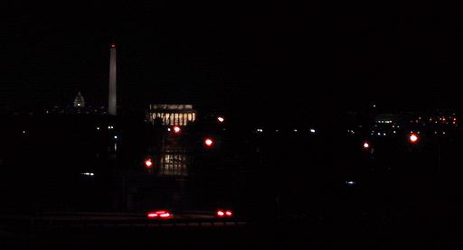
Washington, D.C.
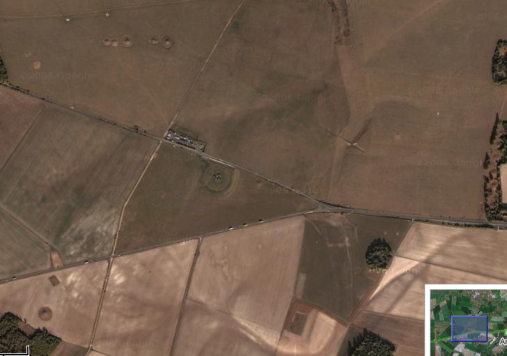
and wow….the middle of nowhere??
Are those crop circles??
Skyline: I concur with the DC.
Satellite: I don’t want to spoil the fun, I emailed Mike D. my answer.
(Who else complained about the lack of skylines? I think it was just whiny little me.)
the skyline was way too easy but i guess you needed to give readers something. Umm… i guess i should feel special cause its my photo
as for the satellite, i’ll go with pennsylvania in the middle of nowhere
I’m taking a wild stab in the dark and saying the satellite is (or is near) Jes Saint’s farm. Well, I don’t know that she actually lives on a farm, but if she doesn’t, then she knows alarmingly too much about tractors and animals.
That Satellite is wicked tough. Here’s my method:
Small towns in various states that begin with either “Ar” “Am” or “An”. Zoom in until the scale is at 1000ft/200m. I’ve already eliminated the towns in Massachusetts, North Dakota, Connecticut, and Pennsylvania.
Helpful hints!
1. Despite the apparent randomness of this field, it is considered a notable world destination. I know, as a fact, that a few of my readers have been here
2. While Aaron’s method, if expanded, will (eventually) return a result… close attention to the circle in the center may shine some light on the correct answer.
Oh man, I’ve totally been there! Not surprisingly, I ended up getting very wet.
I also did not make any blood sacrifices.
Aaron–
I, too, used the name of the town to solve the satellite image. I also noted the color of the road (green, with a slight view of a green block highway label). Basically, I looked for green highways near “Am”, “An”, and “Ar” towns. I zoom out enough so that the scale of the inset map is that of the bigger map, and I think for scanning purposes, I zoomed out one more time. Using tis approach, I was able to find this within 5 minutes.
And then I felt stupid when I found out that this is a well-known destination.
Me: “Hey Mike D, the location is at coordinates X.XX, Y.YY, which is about 2 miles west of A——-, ——-.”
Mike D: “Do you realize what that is?”
Me: “No, lemme go check again.”
[One minute later]
Me: “Is that ———-?”
Mike D: “Yup.”
Me: “I’m a moron.”
Yes, it certainly would take a while using my method. Thanks for the hints folks.
I do live on a farm, and I grew up on one. It’s not satellite worthy, though. :)
Oh hey, is that Stone Henge? Hell, I think I just got a satellite image correct all own my own. But only because that road is on the way to my Grandad’s house so I’ve driven past it many a time.
Um, and the skyline is Washington DC (been there too, but not on the way to my Grandad’s house).
WOW I GOT THEM BOTH I AM AWSOME