Congrats to everyone who pretty much slaughtered last week’s Houston Skyline and Satellite. Bonus points go to JesAbad for driving them roads the same day as the post went up. Also, Roland continues his undefeated record, correctly identifying both locations as within the milky way.
This week’s skyline is a bit different. It’s obvious that the skyline and satellite are of different locations, so we’ll skip the intermediate question.
WARNING: The answer may be in the comments, so don’t scroll down until you feel satisfied with your efforts.
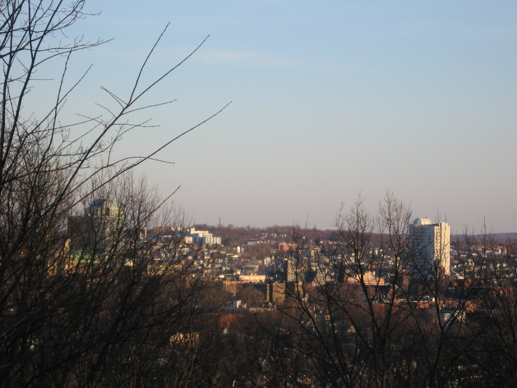
First, identify the skyline. Bonus points if you can identify from where the photo was taken.
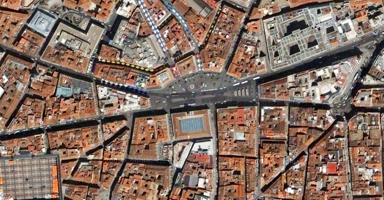
Now, try and identify the satellite.
HERE’S A HINT FOR THE SATELLITE IMAGE:
A,-B
A = the r value for the Ephemeris of MPO 69550 for April 15th 2006
B= the German alloy no. for Grade 2 commertially pure titanium with aSTM-B-specifications for general engineering.
Hint update (B is negative… I mistyped it the first time)
END OF HINT
Good luck!
I’m gonna guess worcester, MA. I’ll say it was taken from I-290.
Somewhere european.
skyline: good lord, I’m never going to get this one.
satellite image: bingo, got it.
Satellite random guess: Rome? It definitely looks Italian.
Cool fact: For the year of 1985, I lived 2.5 miles north of the center of the satellite image.
skyline – Worcester, Ma, from bancroft tower maybe?
satellite – somewhere in france?
definitely beloved Worcester, MA, USA… but the satellite is a mystery
I love how all of the people who know Mike D know that it’s Worcester, and I have no clue. And then ironically, the satellite image is of only one of two foreign cities in which I have lived. Had I not lived there, I don’t think I would have figured it out as quickly (if ever).
Mike D, how did you decide upon the satellite image?
the satellite image was found by searching the globe on maps.google.com
HERE’S A HINT FOR THE SATELLITE IMAGE:
A,-B
A = the r value for the Ephemeris of MPO 69550 for April 15th 2006
B= the German alloy no. for Grade 2 commertially pure titanium with aSTM-B-specifications for general engineering.
END OF HINT
good luck!
lol
So you were just searching Google Maps and thought, “Oh cool, they have detailed maps of A, B. I’ll use it.” ?
I thought maybe you had traveled there before or something.
I’m glad I actually knew where this was. I don’t know if I can figure out those clues.
I got it in a few minutes.
Third hint: GOOGLE.
Well, to be fair Patrick, we all lived in worcester for four+ years
What was the second hint?
Actually, you’re right… that was pretty easy. I figured that Mike D just pulled some numbers from some catalogue on his desk and that I’d never get ’em. (Plus, I was too lazy to Google ’em earlier).
And, I was most impressed that those clues gave the *exact* location of that image. Not just anywhere in the city, but the exact same spot. Well done, Mike D.
Good fix with the negative value. Otherwise, we’d be stranded off the coast of Menorca.