I guess my claim to fame on this website, so to speak, is being the “geography and navigation” expert, mostly because I do a lot of competitive orienteering in my spare time.
I figured it would be fun for everyone to see how I spent about 45 minutes of my time yesterday, at the British Columbia Orienteering Champs in Sumas, BC.
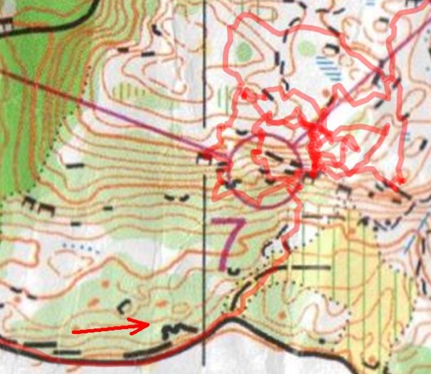
I approached from the south and headed up the rocky hillside (the black specks are all distinct cliffs of various sizes– but in reality there were more rocks out there, just not “distinct” enough to be mapped). My GPS tracker shows that I went right by the checkpoint on my first attempt (the red circle is about 50m in diameter), and then I spent the next several attempts crawling all over that hillside… until I decided to give up and head to the finish. My first ever DNF!
Ha ha ha!
that’s awesome Patrick.
What did you do to get your GPS overlayed on the map? Scan the map and make the GPS fit?
I haven’t run any courses since I got my GPS watch and it’d be cool to do the overlay like that, but I imagine it takes way more effort than I’d be willing to put into doing it. At least it will be exciting to see how much mileage I put on while completing a course.
What did you do to get your GPS overlayed on the map? Scan the map and make the GPS fit?
I use a program called QuickRoute that’s free and developed by an orienteer. It’s got a lot of useful features, like coloring your track based upon your speed or heart rate (if you have a heart rate monitor– I don’t).
Basically, to overlay a track on an image, you just load an image (in my case, a scanned image of my actual map), and load a track file (in my case a .TCX file from my Garmin watch). Then you just match up parts of your track with locations on the map. It’s actually pretty easy.
At least it will be exciting to see how much mileage I put on while completing a course.
Yea, it definitely makes for some fun post-race analysis. However, the International Orienteering Federation just banned GPS watches from being used at certain international competitions. GPS tracking devices are OK, as long as they don’t have a visual display like the GPS watches have. I guess we’ll see how strict they are with this rule, because my race on June 27th is one of the ones impacted by the new rule change.
While most of a GPS functionality is useless as a navigation aid while you’re orienteering, I will say that knowing your exact distance from a certain point would be useful. (For example, if you have 500m in between checkpoints, and your watch says you’ve only gone 400m, you know you haven’t gone far enough yet.) When I run, I only have elapsed time displayed, so that I’m not accused of having an advantage.
Thanks! I have a forerunner 205, I can see why they banned the GPS watches. I only participate in local races so I don’t have much to worry about, not sure what the local club will say about wearing it, I also just wanted to display time but have my watch on so I could download the info later.
Cool! I have a Forerunner 405 which I got last May and have been wearing ever since. I doubt you’ll ever get dinged at a local race for wearing one, but I’m wondering what the trickle-down effect will be. Only 3 races in the USA in 2009 are affected, because they are “world ranking events” administered by the IOF. One of them happens to be near Seattle in a few weeks.
But because IOF has the rule, then maybe USOF will soon follow suit, so all national level events and national champs will ban GPS watches. And then maybe local clubs will follow suit after that. (Again, I seriously doubt it will happen at the local level, but you never know. There are so many other ways of cheating…)