I got an e-mail from Ryan Schenk the other day. Check it out:
If you draw a bounding box around Massachusetts and find the center,
turns out the middle of MA is in Rhode Island.
Where does he come up with this stuff?
my corner of nowhere particular
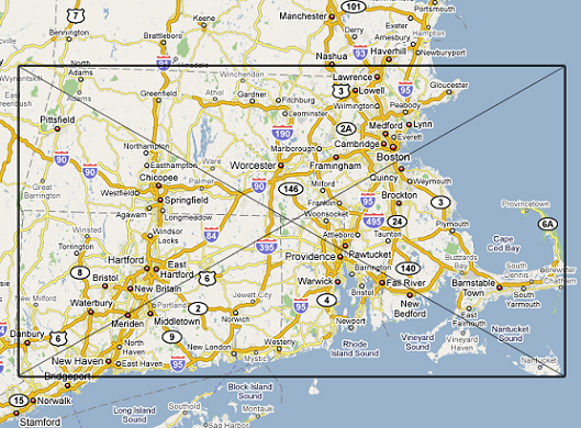
I got an e-mail from Ryan Schenk the other day. Check it out:
If you draw a bounding box around Massachusetts and find the center,
turns out the middle of MA is in Rhode Island.
Where does he come up with this stuff?
That is totally not how you find the geometric center.
Why did he cut out the north shore near NH?
And much of the north shore is cut off!
1) Indeed, the north shore is cut off. If you redo this exercise with that included, the center is back in Massachusetts.
2) The maps are flawed. First, Google Maps uses a Mercator Projection, so there is going to be some map distortion. You’ve got a piece of a sphere represented on a 2-dimensional space.
3) The center location depends on the reference system. In this case, you’re using N-S, and E-W bounding boxes. I just drew a shape on graph paper that has a different “center” depending on whether you draw the bounding box using the paper grids or rotating the grids 45 degrees.
3) In order to find the true center of a region, make a cardboard cutout of the region, then balance that cutout on the end of a pin. There’s also a way to do this was super complicated math, too. When Lebanon, KS was declared the center of the USA (before adding AK and HI), it was done using this method.
4) Massachusetts isn’t the only example of this (even though, as shown above, actually isn’t an example after all). Take a look at Maryland, Norway, and Croatia. Their centers are in Virginia, Sweden, and Bosnia, respectively.
I cut off the North Shore because it’s better off being part of New Hampshire!
Something is seriously wrong with this calculation. The mass above is clearly more than the mass below. This looks like the center of the Kenedy’s voting block instead.