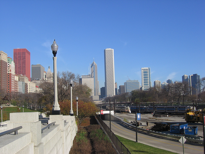
We all remember the skyline challenges of the past. This time I want to try something a little different.
In the past, I’d show you a skyline and a satellite image and you’d have to tell me what cities were represented. This time, I’m going to show you a photo taken of a skyline and you must pinpoint the location on a map from where the photo was taken. Yeah, I think this will be challenging.
So let’s try this one first. The photo was taken in Chicago. Tell me where the photographer stood.
Also… wow. this is extremely challenging. Way more so than I had anticipated. I just tried to find the place where I took the picture, and I’m having a very difficult time. I highly recommend using street view to try and figure out how far you need to be from the monuments.
50 MikeDiDonato.com points if you are the first to identify the satellite location via Gmaps link.
I’m going to guess Van Buren Station in Grant Park
I found it (without even walking down there): 41.869355, -87.622882
You can even see the dumpsters in the pic!
Wow! you even linked with the Latitude and Longitude coordinates! Bravo!!
Really, excellent job. That was not an easy task.
This is extremely close but not quite right.
Not the first answer, I see now, but I found it, too:
41.86937, -87.62291
The train tracks + park made for an easy place to start looking. Found it within 3 minutes.
Yeah well I also solved the financial crisis while I was looking, so it took a little longer.
Actually, I think my coordinates are closer. From the photo, you can tell that the actual position is west of the black chain-link fence. Jocelyn’s position is just east of that fence.
Whew. Good work on that. Thanks.
I pretty much did nothing. But I’m a slacker.
It does appear that Jocelyn mismarked the location on the wrong side of the fence. But given a circumference of the Earth of about 24,900 miles. Her 10 foot error results in about a 0.000007% error.
I think that’s just about within my tolerance of acceptance.
Gotta give it to you though Patrick, your a stickler for details. We’ll toss a dozen mikedidonato.com points your way too.
Also I linked to the GMap image. +50 Mike D points.
Certainly true. I didn’t link.
On a somewhat related note… did you know that the US-Canada border (at least some parts in WA) is off by about 200 feet? The Oregon Treaty of 1846 (and earlier Treaty of Paris in 1783) said that the border would be the 49th parallel, but when they surveyed and marked the border, it’s a bit off.
I have no clue how to figure any of this out.